Explore Our Properties
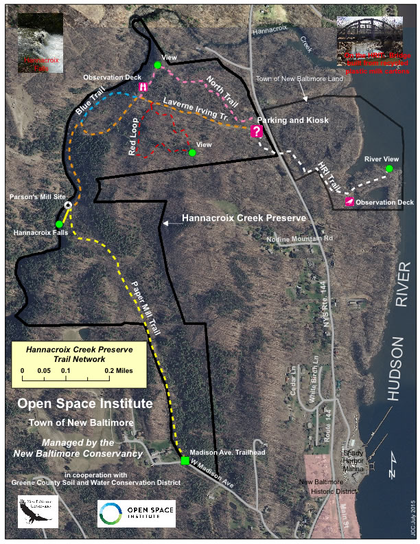
Hannacroix Creek Preserve (HCP)
Step back in time to this 113-acre preserve that bears historical landmarks interwoven with marked trails that provide tranquil spots and outstanding vistas. Some trails will carry you to a scenic overlook, breathtaking waterfall, and the foundation of the old Croswell Paper Mill. While, the 40-acre Hudson River Interpretive Trail (HRIT) leads to the Hudson River shoreline, where one follows a boardwalk through a tidal estuary and crosses the World’s First Recycled Plastic Bridge. While both properties are managed by the Conservancy, the HRIT is owned by the Town of New Baltimore and the Hannacroix Creek Preserve is owned by NBC.
The HCP has 5 major trails, the LaVerne Irving, North, Red Loop, Blue, and Paper Mill trails.
Activities: Dog Walking on Leash, Hiking, Wildlife Watching, Birding, X-Country Skiing & Snowshoeing
World’s First Recycled Plastic Bridge
The bridge was constructed in October of 2000 to allow maintenance vehicles to access the estuary for occasional trash pickup and maintenance. The bridge was constructed by over New Baltimore Conservancy 100 volunteers (yes, we have the sign-in lists) over 3 weekends in October 2000. The bridge took the equivalent of 68,000 plastic 1-gallon milk jugs out of the waste stream. Empire State Development was one of the funders to demonstrate that recycled plastic could work!
Key Features & Trails
LAVERNE IRVING TRAIL
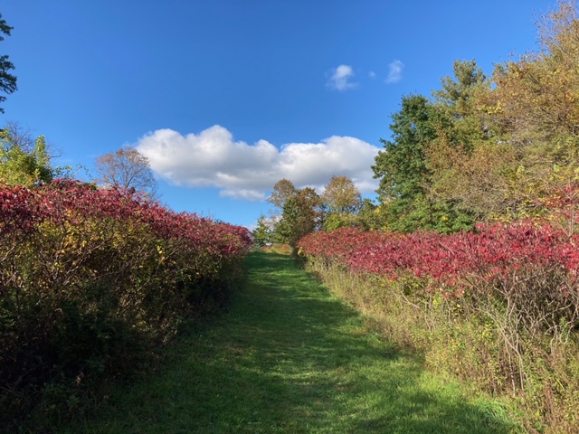
After a moderately steep ascent from the parking area, the Irving Trail serves as the primary walkway through the Hannacroix Creek Preserve. At the top of the ridge, first the RED, then the NORTH and finally the BLUE trails branch off, while the main Irving Trail continues west, dropping down to and paralleling the Hannacroix Creek. The Irving Trail ends at the Hannacroix Creek Falls. The Falls cascade into the Hannacroix Creek over an approximate 20’ drop. The Paper Mill Trail continues south from the Falls, passing by the original poor farm for New Baltimore, then connects to Madison Avenue at the western boundary of the Hamlet. Round-trip from the main parking lot to the falls and back is just under 1.5 miles
RED LOOP TRAIL
The Red Trail is a short loop of a half mile, heading south off the Irving Trail. It quickly Y-s at a log bench. Taking the loop that bears to the right, the counter-clockwise trail passes through nice woods, then a copse of birch, up to a slight mount with views of the Civill Senior Housing roof in Ravena, then drops into a pine glen. It rises again gently, gives way to a splendid view of the Castleton-on-Hudson bridge and railroad crossing, then heads back north to return to the start at the Irving Trail. Witch hazel and May apples abound in the spring.
NORTH TRAIL
Accessible from the trailhead north of the parking lot [back towards the entrance of Route 144], the North trail gently ascends through a protective canopy that houses itinerant spring warblers then turns west and runs along a ridge. Reclaimed not so long ago from a mangle of heavy rose and brambles, machetes used in construction were occasionally lost in the jumble. There is a lovely view down onto the Hannacroix Creek just as the path loops back south to intersect with the Irving Trail, now graced with an observation deck facing west.
LAVERNE IRVING SPUR
BLUE TRAIL
Cutting north from the Irving Trail [just beyond where the North Trail intersects], the Blue Trail passes through an area notable for spring wildflowers. It gives onto scenic views of Hannacroix Creek but is extremely steep and subject to erosion. After crossing the 2012 Scout-volunteer bridge, the trail rejoins the Irving Trail, following the Hannacroix Creek to the falls and Paper Mill Trail.
PAPER MILL TRAIL
The southern end of the LaVerne Irving Trail junctions with the Paper Mill Trail at the old foundation of the Croswell Mill, just east of Hannacroix Falls. Continuing south, the Paper Mill Trail meanders through young woods, passing historic foundations of the town ‘poor farm.’ The Paper Mill Trail ends at the Madison Avenue access to the HCP.
HUDSON RIVER INTERPRETIVE TRAIL
The HRIT [white trail] lies on the east side of Route 144 and is accessed by walking south from the main parking lot, carefully crossing Route 144 to the boardwalk that winds through a cattail marsh. After heading south, the trail T-s. Taking the left leads to the mighty Hudson River. A short way down the trail, on the right, an optional loop leads to an observation deck that looks out onto a tidal pool, home to kingfishers and great blue herons. Spanning the tidally influenced stream is the first recycled plastic-milk carton bridge in the country! The bridge was recently rebuilt following damage from 2011’s tropical storm Irene. After crossing the bridge, the trail leads to the river and the bay at the mouth of the Hannacroix Creek where eagle sightings are common. The round trip is ~3/4 mile.
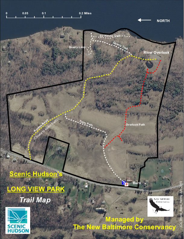
Long View Park
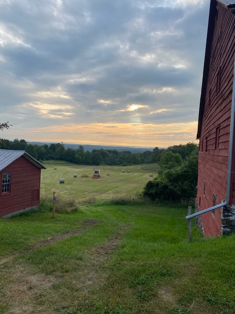
The first thing that greets you upon entering the park is an old red barn, which attests to the land’s centuries-long incarnation as a farm. Today, a profusion of wildflowers bloom in the former pastures, attracting dragonflies, butterflies and birds — and humans eager for close-up connections with nature and the outstanding vistas of the far-off Berkshire Mountains that inspired the park’s name. The trail gradually descends to the Hudson shoreline, affording superb views up and downriver.
Scenic Hudson owns the 76-acre Long View Park which is part of the historic Bronk farm from the mid-19th century that was farmed through the mid-20th century while the NBC manages the property.
Leaving the barn, a mown farm path passes through open fields to be maintained for grassland bird’s habitat. An overlook path leads up to a viewshed then drops through a suite of sumac, turns through a pine glade, passes by a man-made pond to the site of a residence, intended for a previous owner, ending at an overlook with terrific views of the Hudson River and Hoteling Island. Beyond the junction with the Overlook Path, the Farm Path drops down behind a low ridge, following a swale to the original farm equipment access road along the northern edge of the property. It continues towards the river and south, passing through mature woods where eagles are often seen at ridge height just above scouting out the river shore. At height of land, continue south [and loop back to the overlook] or drop-down north along the trail to the quarry area, an amphitheater-like residual of historic quarrying activities, and on the south, along the river to a nice sandy beach and the remains of the ice house foundations.
